A Common Platform for Flow Simulation in Rivers and Lakes
Our laboratory has developed an original simulation model capable of analyzing three-dimensional flows in rivers and lakes. We apply this model to various studies of aquatic environments.
The model, named Tokyo Institute of Technology – WAter Reservoir Model (TITech-WARM), is designed to accurately simulate flows in complex geographical environments, such as meandering rivers and reservoirs located in mountainous areas. It also captures the dynamic behavior of sharp density interfaces, which are characteristic of flows in aquatic environments. To achieve high numerical accuracy, the model employs the CIP (Constrained Interpolation Profile) method, a high-accuracy advection scheme, and a novel computational grid system called the Soroban grid. Although three-dimensional simulations generally require substantial computational time, parallel computing using computer clusters enables us to perform simulations more efficiently.
In addition to calculating spatial and temporal variations in flow velocity, the model incorporates fundamental processes such as changes in water temperature due to meteorological conditions, including air temperature and solar radiation, turbulence, and density variations caused by salinity and other factors. We use TITech-WARM as a common simulation platform for studies of various aquatic environments, extending and modifying the model according to the characteristics of each water body and the objectives of each research project.
Examples of Research Applications
- Saltwater intrusion and the formation of hypoxic water masses in the brackish region of the lower Tone River
- Effects of land subsidence caused by the Great East Japan Earthquake on saltwater intrusion in the lower Shin-Kitakami River
- Modeling of water circulation in Kamafusa Reservoir, including the effects of artificial aeration and circulation systems
- Effects of shallow areas in the middle reaches of the Takase River, Aomori Prefecture, on saltwater intrusion patterns
- Numerical analysis of saline density plumes along underwater slopes in Lake Ogawara
- Effects of shallow areas in northeastern Lake Ogawara on saltwater retention and their relationship with wind conditions
And many other applications.
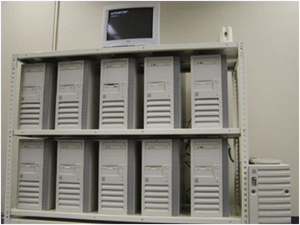
Computer Cluster

Simulation of a Salt Wedge in a Brackish-Water Region Using the Soroban Grid Method
Computational grid points, shown as white circles, automatically concentrate near the freshwater–saltwater interface, improving numerical accuracy.
Simulation of Saltwater Sloshing Using the Soroban Grid Method with Dynamic Adaptive Mesh Refinement